The causes of California’s megafires: Climate change or 150 years of Euro-American mismanagement? Yes and yes.

In a very frank and data-rich webinar, fire ecologist Hugh Safford (USDA Forest Service and research faculty at Department of Environmental Science and Policy at UC Davis) offers “Some ruminations on fire and vegetation trends in California”. He explains the causes of the dramatic increase in megafires and what can be done about it.

A 2,500 year-old tree at Sequoia National Park now needs protection from fires.

The webinar was co-sponsored by the Yolo Interfaith Alliance for Climate Justice and Cool Davis and presented on May 5, 2021.

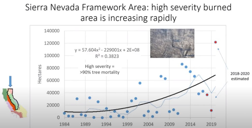
Safford’s presentation starts at 13:23 of the video. The equally enlightening Q&A session begins at 48:20.

Here is a summary of some of the key points:

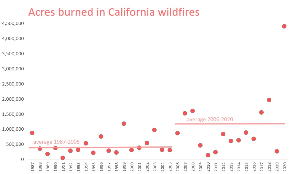
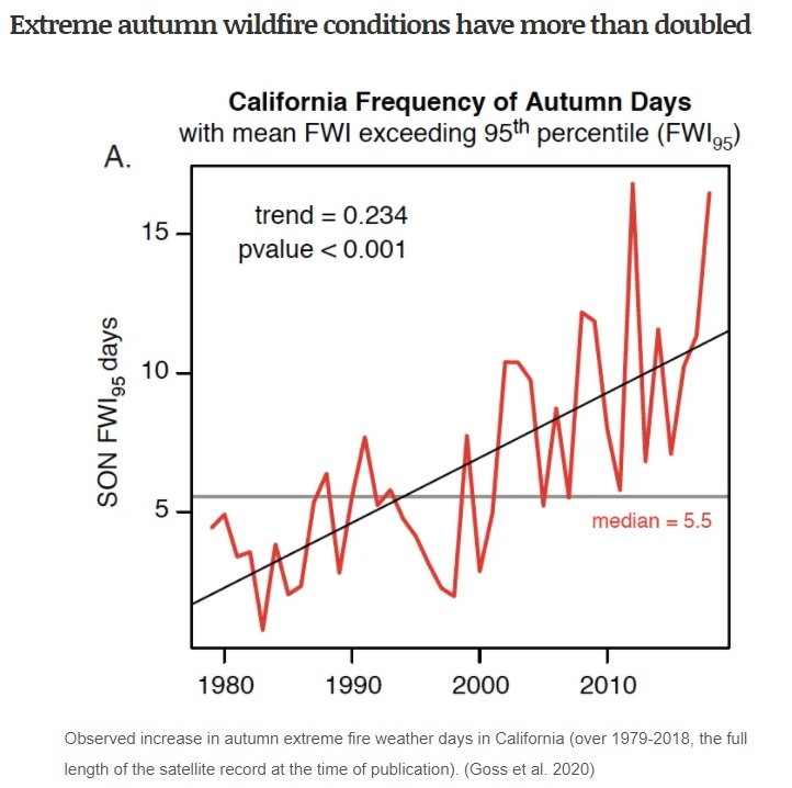
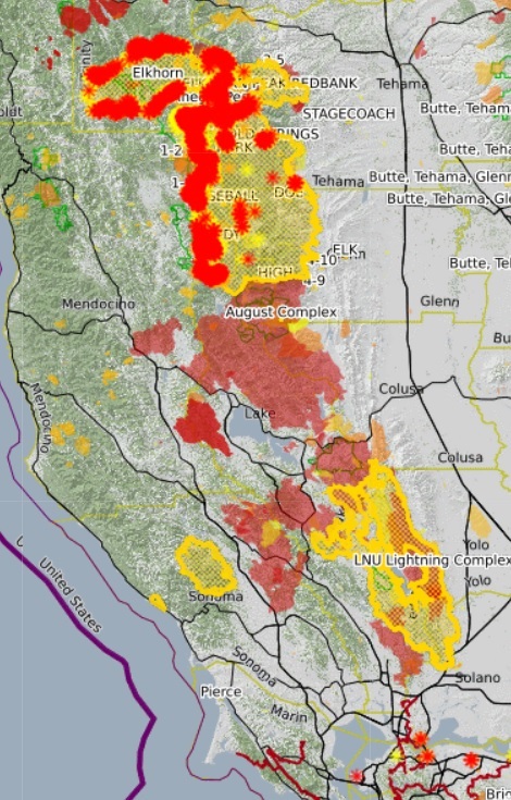
  • The annual burned area has been rising rapidly since the 1980s, almost entirely in northern California.
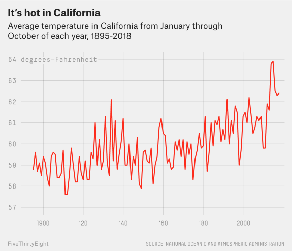
  • This is largely due to fire exclusion caused by the removal of Native Americans as land managers and increased drought and record vegetation dryness caused by climate change.
  • Since 1999, burning over a million acres/yr now occurs regularly; this had not happened before 1999.
  • Pre-EAS (Euro-American Settlement) burning by Native Americans totaled up to FOUR million acres/year (but these were low severity fires that primarily burned the understory and smaller trees).
  • “Euro-Americans, when they showed up in the 1850s, and for that matter today, had no idea how important fire was to the functioning of these ecosystems and they feared it and felt like it was something they needed to stop. After a hundred years of that, it’s really biting us in the butt now because now we have jungles of fuels, we’ve cut most of the big fire-resilient trees out of the system, and when we get the ignitions start we can’t stop the fires anymore. Until about the 1990s, it was easy to put fires out in the forests.”
More mature trees are burning; the acres burned by high severity fires (where more than 90% of trees die) have increased 7x since 2001 in northern Sierra Nevada. 35% of the area of current fires are severe (burn most of the trees); under regular Native burning, this was 5-15%.
  • Pre-EAS forests were at least 40% old growth; current forests are only 6% old growth and highly vulnerable to high severity fires, as they are 4-5x denser than pre-EAS.
  • “Every single fire projection we found in the literature predicts bigger fires, more fires, and more severe fires, basically until we’ve burned so much of California that there actually isn’t much woody vegetation left to burn.”
  • Expect the loss of conifers and an increase in non-native grassland.
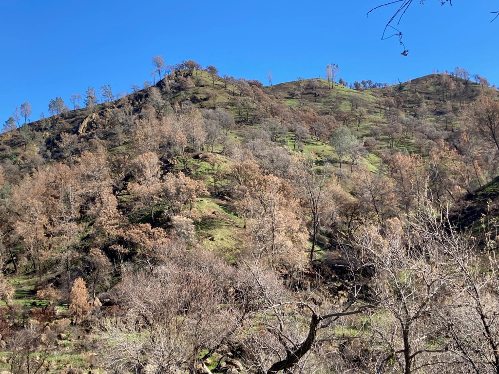
  • Changes already underway: loss of blue oak woodland, ponderosa, yellow pine, and subalpine pine; increase in hardwoods. Loss of sage scrub and chaparral in southern California. Many burned areas are quickly invaded by non-native grasses and will not recover. Incense cedar and white fir may become more dominant trees in California forests.
  • Fires in the Coast Range are now destroying chamise and blue oaks with limited evidence of re-sprouting.
  • In the short run, there’s not a lot we can do to manage climate, but there’s a lot we can do to manage fuels.
  • There’s been a huge renaissance, especially among Native tribes, to use controlled burns to manage forests. California’s new fire resilience plan supports the use of controlled burns. Northern Australia has had great success allowing Aboriginies to manage forests. Opportunities are limited, however, because of development.
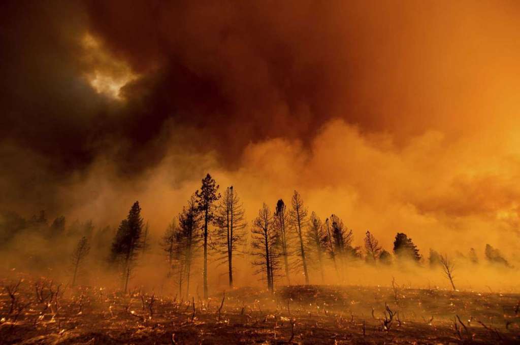
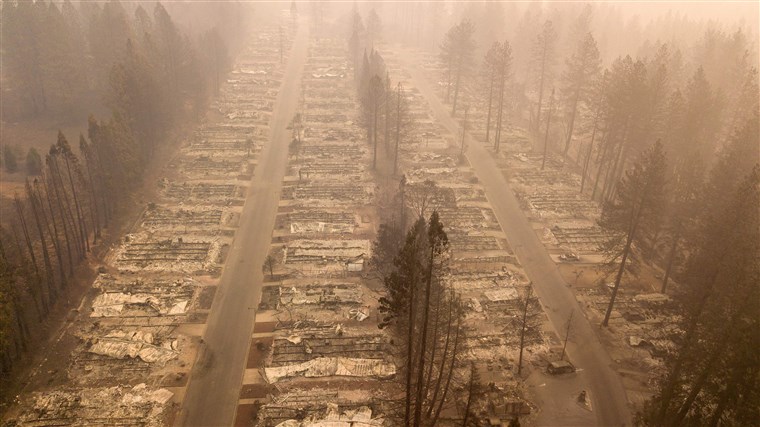
  • The combination of drought cause megafires in the Sierra to produce “Hiroshima-type landscapes”, burning old growth.
  • How to stop fires: Forest thinning is critical, but it’s not economical to harvest small trees, so the government will have to subsidize it. For example, we can use the cut trees for biomass energy, as it done in Scandinavia. This is the only way to save large old growth trees and healthy forests.  “We have to cut a lot of trees. We don’t have a choice…. We can create forests that can handle large fires, or we can sit around and watch it all vaporize.”

Goodbye California: Reminiscences of a climate refugee

There are a lot of reasons why I’m moving from California to Washington, including family and other personal considerations. But one reason, one big reason, is California’s rapidly changing climate.

It was late February in the Coast Range of northern California when I was wearing shorts and a t-shirt. Dust swirled around my car in the dirt parking lot at Cold Canyon. The car thermometer, warmed by a sun that felt imported from Palm Springs, said 87 degrees; it was actually only 77. A hint of ash, omnipresent since The Fire last summer, remained in the air.

Its oaks torched with little hope of return, Putah Creek Canyon is quickly resembling a sun-scorched canyon in Arizona. Until 2018, only one fire in the area had burned more than 15 square miles. Then the County Fire burned 140 square miles. In 2020, the LNU Complex Fire burned 570 square miles.

The hillsides were green with the new growth of non-native grass, which was responding to a recent heavy rain. That was deceptive. More than half the rain we’d had in the previous eight months came in that single event. We had six inches of rain in all of 2020. Looking beyond the grass, nearly every tree – blue oaks and gray pines – on the hillsides was dead, burnt black and orange monuments to a previous era. For our local blue oak woodland, that era ended last year and, given that recruitment of saplings is unlikely due to heat, fire, and cattle, it was an era that will never return.

Massive die-offs are eliminating blue oaks from the southern third of their range. Black oaks are marching up the Sierra, displacing Ponderosa pine, which are marching up, displacing firs. Everyone is on the move. Oak woodlands are becoming oak savannahs, oak savannahs are becoming grasslands, grasslands are becoming rocky high deserts. Arizonification is happening quickly, thru heat, drought, and ultimately, thru fire.

Virtually all of the east slopes of the Coast Range between San Francisco Bay and the Trinity Alps has burned in the past ten years. In the Sierra, one can practically predict where the next fire catastrophe will happen, because it hasn’t burned yet (hint: Lake Almanor, Placerville, Arnold).

The Fire, the LNU Complex Fire, was part of 2020’s 4.3 million acres of scorched earth. The LNU Fire exceeded the total acreage of all previous fires that impacted my county over the last 50 years combined.

It was a beautiful day—for April. But February has become April, April has become May, and June, July, August, September, and even October and November have become unrecognizable. Every year more heat records are broken. Hottest summer, hottest month, most days over 100, most days over 90. The list goes on, each year breaking the records set the previous year. Weather data is normally highly variable; now it is a straight line—warmer and warmer. And smokier.

My cape honeysuckle and bougainvillea, both planted with a degree of optimism outside their recommended zone, used to die back so badly in the winter that each spring I was tempted to declare them dead and pull them out. Now they bloom year-round, looking like they’re in a courtyard at a hotel in the tropics. We haven’t had a real freeze in seven winters.

The songs of lesser goldfinches on my street are a depressing warning. I can’t take two steps outside without seeing or hearing a bird that reminds me that our climate has seriously changed. Western tanagers, house wrens, and turkey vultures are regular in winter now. The lesser goldfinches have come out of the arid hills and are quickly becoming one of the most ubiquitous nesting birds in Davis. (I know this definitively because one included an imitation of a canyon wren in its song.) What’s more, at least four Say’s phoebes, essentially a high desert species, are scouting for nests in town now. A fifth arrived on my block last week, singing as if on territory. They’ve been doing this for a few years and their numbers are growing.

The graphs of acres burned in California (and in other western states) and the expansion of some bird species into the Pacific Northwest (in this case, Anna’s hummingbirds in winter), are strikingly similar.

I’m leaving. I’ve lived in California fifty-five years but it’s no longer the state I grew up in.

We’re headed to the Olympic Peninsula in Washington. We are fortunate to be able to do so.

Besides the cooler summers, one of the best things about moving to a new place is that I won’t be reminded of climate change on a daily experiential basis. Because the ecosystem will be new to me, I won’t know what’s different, what is changing, except maybe for the brown boobies, a tropical seabird, that are now showing up in Puget Sound each year. Or the family of California scrub-jays that have just established residence on my new street. Like Anna’s hummingbirds, black phoebes, great egrets, red-shouldered hawks, and people like me, scrub-jays are moving north. I expect more of California’s birds to follow me, just as I follow some of them. Yes, lesser goldfinches are coming north too; they’re already established southeast of Tacoma.

I feel like a frog in a boiling pot. I’m getting out. I’m saying goodbye to California, but I feel it has left all of us without saying goodbye to anyone.

The view from Point Wilson, a mile from my new home in Port Townsend, which has had only a few nights below freezing all winter. Climate change is occurring there too, but remains well within temperate ranges.

I do believe that Homo sapiens may ultimately win the climate battle and bring atmospheric CO2 back down to 300 ppm or something. But that’s a hundred years off. And there’s no guarantee we can stop the tide of Greenland and Antarctic ice melt to prevent sea level rise. In the meantime, in the next 50 to 100 years, it’s going to get a lot warmer. And we may ultimately lose New York City, Singapore, Mumbai, and every other low-lying coastal city. My new home is fifty feet above sea level. Well, probably forty-nine and a half now.

Becoming Arizona: How climate change is transforming California thru fire

When climatologists predicted that Sacramento would have Phoenix’s weather by 2100, and Portland would have Sacramento’s, they didn’t explain the ecological implications nor the process. Yet it’s apparent that an awful lot of trees need to disappear for the Sierra to look like the rock, grass, and cacti that make up Camelback Mountain in Phoenix.

Camelback Mountain near Phoenix

A new “new normal” every year

This ecological transformation, the likes of which would normally take a thousand years even during a rapid warming event, is happening, driven by rapid climate change. All those trees are flying away in the form of ashes and smoke.

The process, in human and ecological terms, is brutal. Californians experience a new “new normal” each year, each one stunning in its own right. In 2017 we were shocked when 6,000 homes burned in Santa Rosa, killing dozens as people fled in their bathrobes. Despite decades of fires in suburban California, there had never been anything of that magnitude. Before the year was out, the Thomas fire became the largest in state history as it burned thru Christmas and New Year. The next summer, the Carr fire stunned us with an EF-3 firenado that generated 140 mph winds. A few months later, the past was eclipsed when the entire town of Paradise burned, killing 85 people. That may be the largest climate-induced mass mortality event in history.  

2020

After a reprieve in 2019, we arrive at 2020, where acreage burned has exceeded two million and three million for the first time. We keep having to adjust our vertical axes to make room for each new year. Five fires burning at the same time in 2020 qualified for the top 20 largest fires in the history of the state. Three of those, still burning as a write, are first, second, and fourth on the list.

California under smoke, September 9, 2020.

Each year has its macabre highlights. This year, over 300 people were rescued by military helicopters, many at night high in the Sierra. For the first time ever, all 18 national forests were completely closed to the public. The National Weather Service had to create a firenado warning. A dystopian pall of smoke created hazardous air from California to Canada for weeks, forcing people into their homes with all windows shut. And my hometown, Woodland Hills, hit 121 degrees, the highest temperature ever recorded in Los Angeles County.  

In 2019, the media reported that Oregon firefighters make an annual trek to California to provide mutual aid. In 2020, that changed. A quarter of the west slope of the Cascades from Portland to Medford appears to be on fire. One out of eight Oregonians are evacuating. The media is filled with horrific stories of grandmothers and teenagers burned alive while the father asks a badly burned woman along a roadside if he’s seen his wife. “I am your wife,” she responds.

Eugene, Oregon on the morning of September 8, 2020.

The process

We have heard for years that, with longer and hotter summers and declining snowpack, fire season has grown by months. In 2006, Westerling predicted such an increase in fires that the forests of the western US would become net carbon emitters. The US Forest Service now plans for fire year-round.

A series of academic analyses lays out the factors and processes of Arizonification. Decreased summer rains, as well as warmer winter and spring temperatures, are creating dry and stressed trees. But that’s not all. Summers that have become 1.4C (2.5F) warmer have led to an exponential increase in atmospheric vapor pressure deficit (VPD). It’s getting drier and, more importantly, vegetation is getting drier. This leads to big fires. Williams et al (2019) noted, “The ability of dry fuels to promote large fires is nonlinear, which has allowed warming to become increasingly impactful.” The Camp Fire, which destroyed the town of Paradise, occurred during some of the lowest vegetation moisture ever recorded. Add to that hot dry winds and vulnerable PG&E transmission lines, and the Paradise disaster looks predictable.

Northern California, being at western North America’s southern edge of the low elevation temperate forests, is especially at risk. As documented in the Verdugo Mountains near Los Angeles, high fire frequency converts forest and chapparal to weeds and rocks. That southern edge is pushing north. Forests are migrating north; so are deserts. (So are bird populations.)

To summarize, slightly warming temperatures, even in winter and spring, and less summer rain lead to an exponential increase in dry vegetation, which leads to an exponential increase in large fires, which leads a conversion of habitat from forest and chaparral to the grass and rock-dominated landscapes of arid desert mountain ranges. Sacramento becomes Phoenix. The Sierra and Coast Ranges become Camelback Mountain.

The future

Nearly the entire east side of the northern Coast Ranges have burned since 2018. Much of the southern Sierra forests died during the recent drought; most of those have yet to burn.

Arizona State University fire historian Prof. Stephen Pyne calls this a new epoch, the Pyrocene. “The contours of such an epoch,” he writes, “are already becoming visible through the smoke. If you doubt it, just ask California.”

Abatzoglou and Williams (2016) conclude, “anthropogenic climate change has emerged as a driver of increased forest fire activity and should continue to do so while fuels are not limiting.” Williams et al repeat this, “Given the exponential response of California burned area to aridity, the influence of anthropogenic warming on wildfire activity over the next few decades will likely be larger than the observed influence thus far where fuel abundance is not limiting.”

In layman’s terms, it’s going to get worse until there’s nothing left to burn.

The annual area burned in California has increased fivefold from 1972 to 2018 (Williams et al 2019). Several individual fires in 2020 exceed the average from 1987-2005. The point shown here for 2020 is still increasing.

Academic papers

Here is a partial list of recent research on the increase of fires in California and the western US.

Abatzoglou and Williams (2016). Impact of anthropogenic climate change on wildfire across western US forests. PNAS 113 (42) 11770-11775.

Goss et al (2020). Climate change is increasing the likelihood of extreme autumn wildfire conditions across California. Environmental Research Letters 15(9).

Haidinger and Keeley (1993). Role of hire fire frequency in destruction of mixed chaparral. Madrono 40(3): 141-147.

Holden et al (2018). Decreasing fire season precipitation increased recent western US forest wildfire activity. PNAS 115 (36) E8349-E8357.

Kitzberger et al (2017). Direct and indirect climate controls predict heterogeneous early-mid 21st century wildfire burned area across western and boreal North America. PLOS One.

Lareau et al (2018). The Carr Fire Vortex: A Case of Pyrotornadogenesis? Geophysical Research Letters 45(23).

Seager et al (2014). Climatology, variability and trends in United States 2 vapor pressure deficit, an important fire-related 3 meteorological quantity.

Swain (2020). Increasingly extreme autumn wildfire conditions in California due to climate change. Weather West Blog (related to Goss et al 2020 above).

Syphard et al (2019). The relative influence of climate and housing development on current and projected future fire patterns and structure loss across three California landscapes. Global Environmental Change 56: 41-55.

Williams et al (2019). Observed Impacts of Anthropogenic Climate Change on Wildfire in California. Earth’s Future 7(8): 892-910

Westerling et al (2006). Warming and Earlier Spring Increase Western U.S. Forest Wildfire Activity. Science 313(5789): 940-943.

Hell in Paradise: Why the Camp Fire was the largest climate-induced mass mortality event in modern history

fires Paradise

The Camp Fire was started by downed power lines, spread from a forest, and then became a structure-to-structure urban fire in which houses burned but many trees did not.

I grew up in southern California on the edge of the San Fernando Valley. Fires, usually fueled by Santa Ana winds on dry grasses in the hills, were a fact of life. I evacuated. I ran the pump to squirt water from the pool onto the roof. I helped neighbors on the edge of the hills water their roofs. Back in those days, in the 1970s, fires over 100,000 acres (~150 square miles) were rare. The worst fires destroyed 200 to 300 homes. Rarely, someone died. That was then.

fires infographic

Infographic prepared in 2013, before most of the recent mega-fires.

Twelve years ago, four researchers examined a comprehensive database of all large wildfires in western United States forests since 1970. They detected a signal and concluded that “large wildlife activity increased suddenly and markedly in the mid-1980s.” Looking at weather data and land-use history, they concluded the driving factor was “increased spring and summer temperatures and an earlier spring snowmelt”. Forest management, on the other hand, had “relatively little effect”. Published in the journal Science in 2006, they had found the “force multiplier” that climate change brings to the West. We all knew that forests had been mismanaged for nearly a century, and that too many homes and towns had been built up against wildlands.  But now there was a new factor driving fires—longer hotter drier summers. If you’re looking for numbers, the data show that fires really ramped up in 1987.  The so-called “force multiplier” of climate change was big—about 3 or 4. That is, wildfire frequency was triple in dry years when compared to moderate years, and quadruple that in wet years. Ominously, they noted the effect was non-linear, meaning that, in warmer years, fires really increased. Thus, the multiplier was not just a constant number—it increased with temperature and lack of rain. The Berkeley Tunnel fire, which was exceptional because it killed 24 people trying to evacuate and was the first fire in California history to burn over a thousand homes (it actually burned over 2,000 homes), occurred in 1991.

In the twelve years since the Science article, mega-fires, in terms of acres burned, structures destroyed, and people killed, have gone off the charts—literally. When it comes to fires that burn more than 200,000 acres (~300 square miles), destroy more than a thousand homes, and kill dozens, if not hundreds of people, climate change is not really a “force multiplier”, it’s an on-off switch. Such fires were very rare or non-existent before the year 2000. Now, they appear to be annual.

CA fires 2b

We’ve crossed a threshold, tripped a wire.  In 2017, after the astounding loss of 6,000 homes in Santa Rosa, we hoped that was an outlier, a blip in the data. A few months later, in December, when fires were previously unheard of, the Thomas Fire became the largest in state history. Barely six months later, the Carr Fire made Redding “the new Santa Rosa”. After that fire I posted a chart showing that 16 of the state’s largest 20 fires had all occurred in the past 20 years. We had a reached a “new abnormal”. Then, a few months after that, in November, when by all historical standards the fire season should be over, the Camp Fire literally wiped out the entire town of Paradise, population 26,000. Hospitals, high schools, stores, and houses, all gone. The death toll is without historical precedent. While that was burning, the Woolsey Fire became the largest and most destructive fire in the history of the Los Angeles area. At the present rate, next year the Paradise inferno will be surpassed by some hell unimaginable.

CA fires 2a

When I say the Camp Fire is the largest climate-induced mass mortality event in modern history, I’m not counting hurricanes. Hurricanes, even large hurricanes, have always occurred and always will. A Category 5 hurricane striking a major city is an inevitability. Yes, climate change has made hurricanes larger and more numerous, thus increasing the risk, but nothing like the change we’ve seen with fires in the West. Thus, attributing any one hurricane to climate change is like attributing a single specific cancer case to an environmental contaminant causing a cluster of cases.

CA fires 2c

When I say the Camp Fire was caused by climate change, I’m not saying that future destructive fires are inevitable. The fires will come, but we can do things to mitigate the

science-fires-1

Graphic from fivethirtyeight.com

destructive aspects. A full post-mortem on the Camp Fire and other recent mega-fires is of course required. Such analysis should look beyond the political rhetoric of Trump, exclusively blaming management practices in national forests. Most of these fires in these graphs, spreading across dry grass and oak woodland, had nothing to do with forests. Furthermore, in the face of massive tree death from drought, simply removing dead trees from forests has serious feasibility limitations. To quote a forest fire expert colleague, “Yes, fuels reduction is needed same as 30 years ago, but the mills are all full from the tree mortality supply, much of the fuels are not merchantable, and we are not going to cut our way out of longer fire seasons and deadly MegaFires.”

In the short run, we can’t stop the changing climate, the record low humidity and record high dry vegetation, or the longer summers. We can’t shorten the fire season, now 80 days longer than in 1970s. But we can modify power lines, conduct preventative burns, revise urban fire perimeter requirements, and re-evaluate evacuation routes. Those things won’t turn off the switch we’ve triggered, but they might at least save some homes and lives in the coming years.

CalFiredamage

The CalFire damage inspection map of Paradise. The latest interactive map can be found here

California apocalypse again: Large wildfires increasing with climate change

smoke

Sunset from the Central Valley, looking toward the Coast Range through the smoke of a million trees.

As I write this, helicopters are passing overhead in a dim gray-brown sky. The sun is a pink orb over the western horizon. It is 97 degrees at 7pm. The people of California sit like frogs in a slowly boiling pot.

Average temperature for July and August, here in Davis, is 93 degrees. But in the past 34 days, it was only below that six times. July 2018 was the hottest month in the history of the state.

Such climate change was predicted, with great accuracy, by both oil companies and government scientists back in the 1980s, and even earlier.  The consequences of this included more extreme weather, more drought, shorter rainy seasons, earlier snow melt, longer fire seasons, and larger fires. All that is coming to pass in such dramatic fashion that new records are set each year.

[CLICK TO ENLARGE GRAPHS]

Note: There were more mega-fires in November, 2018, shortly after I wrote this. These graphs are updated in a more recent blog post “Hell in Paradise: Why the Camp Fire was the largest climate-induced mass mortality event in modern history”

CA fires1In 1988, scientists were excited– and alarmed– to see the first indications of a warming climate. Now, graphs illustrating climate change need no statistical analysis. They are obvious to a child, ramping steeply up with each passing year.

CA fires2

A conservative talking point seems to be that this dramatic increase in fires is not due to climate change, but to poor forest management. While this has been an issue for over a hundred years, this question was the prime focus of Westerling et al 2006 in Science, where he concluded that longer hotter summers and shorter drier winters were indeed to blame. There were increased fires even in areas without poor management– or any management at all. Where there has been poor forest management, climate warming has acted as a “force multiplier” to make fires even worse. One could only imagine how easy it would be to write that paper now, twelve years later, with plenty of new eye-popping data points.  Thirteen of California’s 20 largest fires have occurred since Westerling sent his paper to the publisher.

Perhaps the best illustration of the combined effect of poor forest management and climate change comes from this 14-minute Ted talk given by Paul Hessburg in 2017.

Using a useful forest diagram, he explains how Native Americans regularly burned underbrush and maintained an open forest/meadow ecosystem that effectively prevented large wildfires. In the late 1800s, with the ethnic cleansing of Native Americans, the advent of cattle that ate the grass, and the US Forest Service suppressing fires and logging the largest trees, our forests changed from a mosaic of tough old trees surrounded by natural fire breaks to a solid crop of young growth. Add drought, heat, and an ignition source, and you see the results above.

CA fires3

The solution, regardless of how much you attribute large fires to climate change or management, is the same. We need to re-create the balance of the past thru the protection of large trees and prescribed burns. We need to create meadows and healthy forests. Some Native communities in northern California are planning to do this.

This all assumes that we get enough rain in winter and cool temps in summer to allow re-growth. Otherwise, the current fires may be transforming California’s mountain habitats into something resembling the mountains of Nevada and Arizona in the span of a decade.