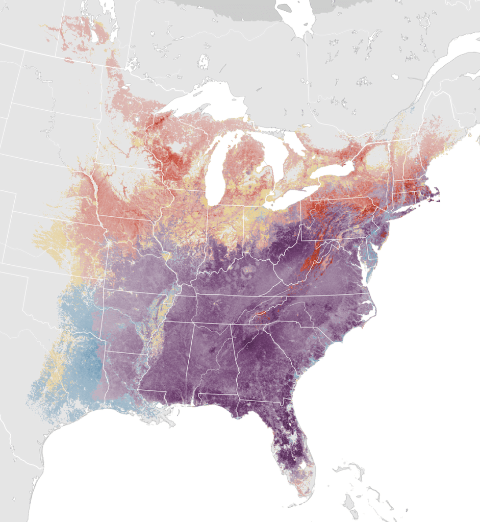
eBird abundance map for Eastern Towhee. It is resident in the southeast, but expands north in summer.
The Eastern Towhee, a bird of scrub and thickets, is a common resident in the southeast United States. One subspecies migrates north in summer.
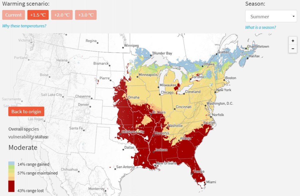
They are a prime example of a species that is considered “Least Concern” by the International Union for Conservation of Nature (IUCN), but “High Risk” in National Audubon’s assessment of birds under climate change. In their 3.0 C scenario, they predict it would lose 83% of its current breeding range, while gaining only 23%.
This is National Audubon’s projection for the Eastern Towhee’s breeding range under just a 1.5C scenario. This would spell extinction for the white-eyed birds of Florida and the deep South.
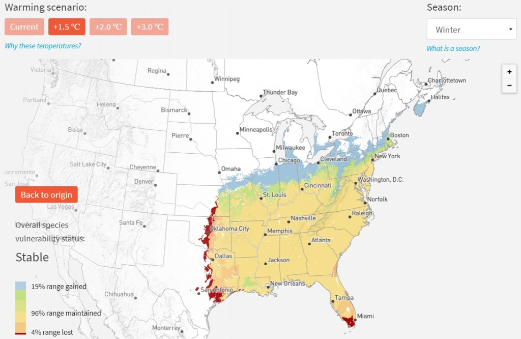
Their winter range is not anticipated to change much.
These projections are consistent with recent literature showing poleward shifts of species ranges– of the northern edge of their range, of the southern edge, and of their range’s geographic center. The predictions for Eastern Towhee are among the most dramatic.
Recent research also suggests that non-migratory and short-distance migrants are more adaptable to climate change than are long-distance migrants, and more able to shift their ranges. Indeed, we are already seeing that with Eastern Towhee. The Audubon projections appear to be in progress.
Based on Breeding Bird Survey (BBS) data, the Eastern Towhee breeding population in Florida has declined over 50% since the late 1990s. The timing of this is consistent with worldwide ecological shifts which began in the mid-1980s.
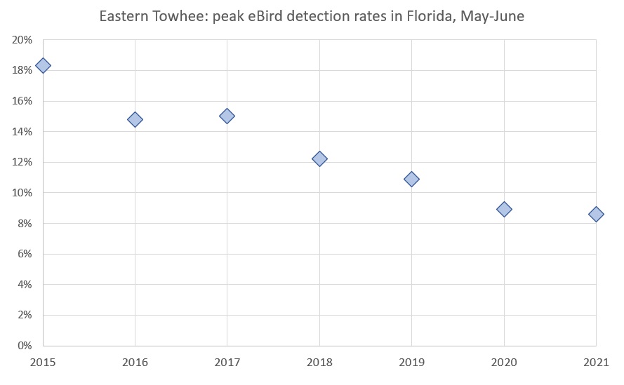
The white-eyed subspecies appears to be already in trouble. eBirders in Florida in May and June are encountering the species half as often as they were just six years earlier.
eBird data from Florida, focusing on frequency of lists reporting the species during the May-June period, shows that the maximum frequency has fallen from 18.3% in 2015 to 8.6% in 2021.
Not all range shifts are due to climate. As a scrub specialist, the Eastern Towhee prefers habitat that is in the act of regrowth, such as after a fire or being cleared. But they don’t want a forest either. To quote the Birds of the World species account for Eastern Towhee: “As farmland is abandoned, successional changes produce suitable midseral habitats that towhees favor, and their numbers increase. But, successional time is against towhees, and their numbers decrease as seres age.” That may be the explanation for the Georgia data (orange dots), which show a decline in the late 60s and early 70s, possibly due to forest growth or land clearance for development, and then a leveling off.
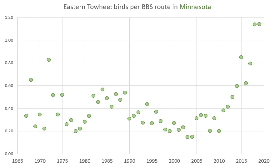
As the climate warms, many species are expanding north and/or declining in the southern part of their range. But these need not happen simultaneously. Opportunities for suitable habitat may open doors in the north, and doors may close in the south, at different times. There is evidence of Eastern Towhee expansion in Minnesota, but look at the vertical axis; it does not compare with the losses in Florida.
In Florida, the white-eyed subspecies faces extinction based on National Audubon’s 1.5C scenario. They appear to have declined dramatically in the past two decades.
Despite all the attention on the new Biden Administration’s efforts to combat climate change, one state, California, is reshaping the world’s oil markets through its progressive climate policies.
Many cities in California – Oakland, San Francisco, Sacramento, San Diego – now exclusively use RD in city-owned heavy-duty trucks, buses and equipment.
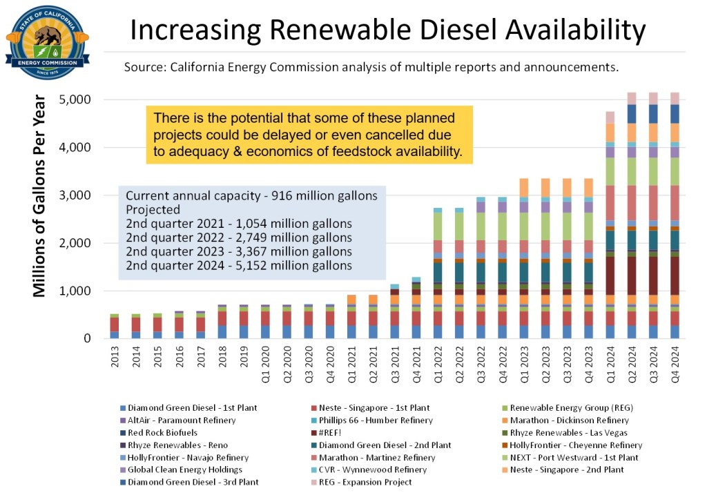
Renewable diesel already accounts for 20% of California’s diesel supply and is projected to grow well beyond 50% by 2024, expanding to include jet fuel, where it is called “sustainable aviation fuel,” or SAF. Renewable propane is also produced during the refining process. Renewable gasoline, unfortunately, is still not economically feasible.
California’s RD comes from a variety of sources. It is imported from Singapore (Neste) and North Dakota. At the latter, the Marathon refinery in Dickinson, North Dakota, originally built to refine fracked Bakken oil, has converted to taking soybeans to make RD for the California market.
The California Energy Commission has identified enough proposed RD projects to supply all of the state’s needs in the future.
Increasingly, refineries in California are ramping up to produce RD from local feedstock. Two of the state’s largest refineries, Phillips 66 and Marathon in the Bay Area, are currently closed, using the Covid downturn to retrofit their operations into making RD. They will each produce 20% of the state’s diesel in the form of RD; they will completely cease using crude oil as an input. Other smaller refinery conversions are underway in southern California.
The California Energy Commission (CEC) projects that the state’s overall oil use, already down 20% due to the pandemic, will scarcely rebound and then continue declining in the future.
At the state level, California’s ever-lowering cap of tradeable permits under the AB32 cap-and-trade program is finally biting hard enough to change incentives. Carbon credits are now yielding about 30 cents/gallon and is likely to rise. Because this comes from traded permits, it is not a direct payment from government funds.
Combining federal and state incentives, a refinery converting from conventional to renewable diesel reaps an additional $1.30/gallon. If the Phillips 66 project goes to its full 800 million gallons/year, that’s at least a billion dollars each year in subsidies – from tax credits and tradable carbon credit sales.
California has already reduced greenhouse gas emissions 15-20% since the peak in 2004. This has been achieved during a period of significant economic and population growth; emissions per gross domestic product are down about 45%. Because the transportation sector has been among the most challenging for reducing emissions, the RD revolution will go a long way to helping California reach net zero by 2050. The Biden Administration is using California’s carbon reduction measures as a model for the nation.
The RD revolution is a transition to more dramatic decreases in oil use due to electrification of the vehicle fleet.
Researchers from UC Davis collect acorns in arid west Texas to plant on their campus in northern California. They estimate their climate in 2100 will be similar to that of Barstow or even Phoenix today. City staff from a town near Portland, Oregon travel to California and Arizona for seedlings they can take home and plant along their city streets. They are preparing for Portland’s weather to become like Sacramento today.
The range of Arizona oak. For one town near Portland, Oregon, the list of potential future street trees includes this species, as well as California buckeye, California laurel, and silverleaf oak.
With these regions breaking new heat records annually – Sacramento just topped 90 degrees for the 110th day (and counting) in 2020—and given that trees take decades to mature, the race is on. Birds can fly, mammals can walk, but trees expand their ranges very slowly. Most acorns from an oak end up within a few hundred yards from their home tree.
Climate velocity, the speed at which ecotones are shifting north, is much faster than that. Our climate is changing ten to one hundred times faster than during a global warming event 55 million years ago known as the Paleocene-Eocene Thermal Maximum (PETM). During that “rapid” spike, palm trees successfully migrated to the Arctic circle, but they had thousands of years to make it there.
Dead blue oaks in Fresno County, California. They experienced excessive mortality during the 2012-16 drought. These hills may revert to grassland. Researchers want to use the genes of the survivors as stock for the future in the north. For a full presentation of blue oak gene-assisted migration see this presentation by the California Department of Fish and Wildlife.
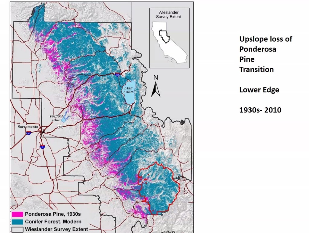
While trees can’t walk, they can die. Range contraction of trees along their southern xeric (dry) edge is happening in the American West right with the speed of climate change. Blue oak die-offs are widespread in the southern third of their range. From California to Colorado, conifers such as Ponderosa pine and Douglas-fir are disappearing from lower elevations. To quote Davis et al (2019), “In areas that have crossed climatic thresholds for regeneration, stand-replacing fires may result in abrupt ecosystem transitions to nonforest states.” When people talk about California becoming Arizona, the cleanup hitter in that process may be fire, but the first batters are heat, drought stress, and bark beetles. After fires, decreased soil moisture and increased vapor pressure deficit (VPD) associated with climate change are leading to reduced probability of regeneration (Davis et al 2019). In short, many forests are not coming back.
Ponderosa pines are disappearing from lower elevations of the Sierra in California. This has been documented in Colorado as well.
Recent mega fires include many of the drought-killed conifers in the southern Sierra. Research suggests regeneration may be imperiled due to a warming climate.
Researchers have discussed facilitating tree migration due to climate change for over a decade (Aitken et al 2008). For over a hundred years, botanists have recognized regional differences within the same plant species, and simple garden experiments have shown that local varieties do better. The standard rule of thumb has always been that local varieties are best; they are adapted to the local ecological niche. Now that is changing.
Recent research is showing that trees are now in the wrong places; the climate has shifted past them. Valley oaks, white fir, Douglas fir, ponderosa pine, Western hemlock, and lodgepole pine seedlings all do better when removed from their original home and moved north (Aitken and Bemmels 2015).
The local trees are becoming misfits in a world that is changing around them. Many researchers are hesitant to fully embrace assisted migration; introducing non-native species has a horrid track record. But they are beginning to study “assisted gene flow”, moving hardy trees from the southern end of a species’ range to the north end. Cities, on the other hand, are beginning to see trees as more than just aesthetically pleasing; they are critical infrastructure, providing shade and reducing urban temperatures. So the cities and towns are moving faster, boldly cultivating trees from the dry Southwest into the Pacific Northwest. Likewise, the government of British Columbia is not hesitating. Assisted migration of Western larch and whitebark pine in Canada is already underway.
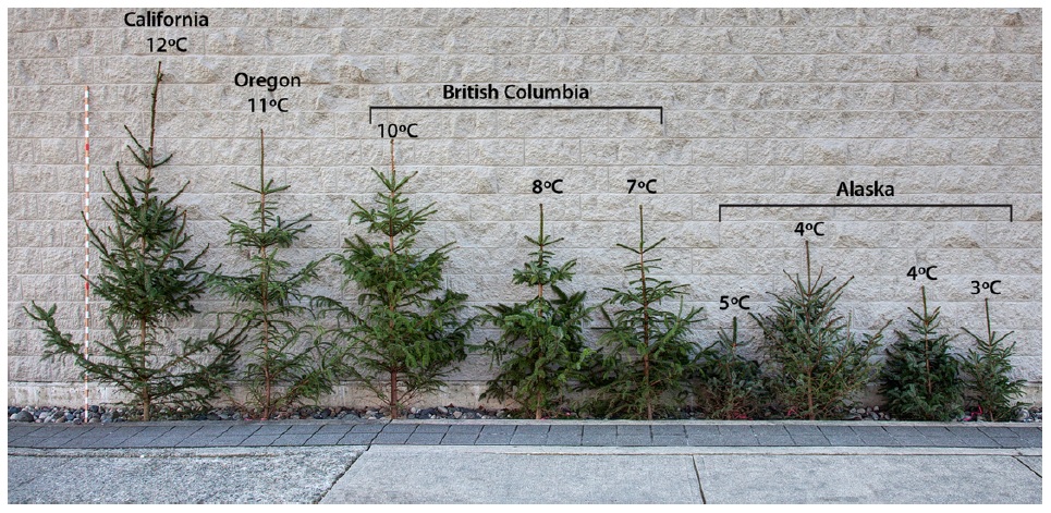
This photo from Aitken and Bemmels (2015) shows a series of Sitka spruce, all eight years old, planted together in British Columbia. The trees from the south, adapted for a warmer and drier environment, are out-competing the locals.
Tree migration is also critical for the range expansion of animals. Without the trees and other vegetation, many birds, mammals, and other forms of life have no habitat rungs on the ladder to enable them to move north as well. Anna’s Hummingbirds now winter in Canada and even Alaska, largely due to ornamental plantings. The Oak Titmouse, on the other hand, is dependent on oaks, tightly constraining its ability to expand north. It may be that, in the coming decades, oaks and other tree species planted in cities and towns will provide critical refugia for a wide variety of birds and insects seeking cooler climes.
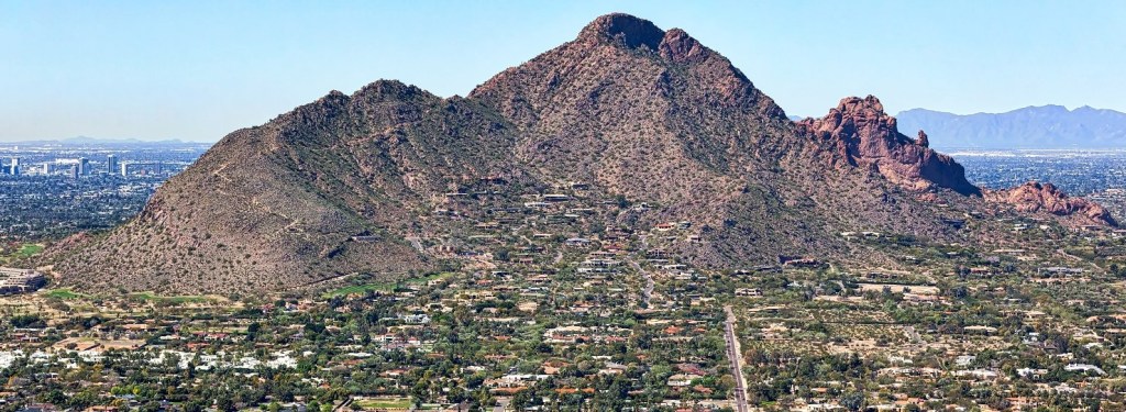
When climatologists predicted that Sacramento would have Phoenix’s weather by 2100, and Portland would have Sacramento’s, they didn’t explain the ecological implications nor the process. Yet it’s apparent that an awful lot of trees need to disappear for the Sierra to look like the rock, grass, and cacti that make up Camelback Mountain in Phoenix.
Camelback Mountain near Phoenix
A new “new normal” every year
This ecological transformation, the likes of which would normally take a thousand years even during a rapid warming event, is happening, driven by rapid climate change. All those trees are flying away in the form of ashes and smoke.
The process, in human and ecological terms, is brutal. Californians experience a new “new normal” each year, each one stunning in its own right. In 2017 we were shocked when 6,000 homes burned in Santa Rosa, killing dozens as people fled in their bathrobes. Despite decades of fires in suburban California, there had never been anything of that magnitude. Before the year was out, the Thomas fire became the largest in state history as it burned thru Christmas and New Year. The next summer, the Carr fire stunned us with an EF-3 firenado that generated 140 mph winds. A few months later, the past was eclipsed when the entire town of Paradise burned, killing 85 people. That may be the largest climate-induced mass mortality event in history.
2020
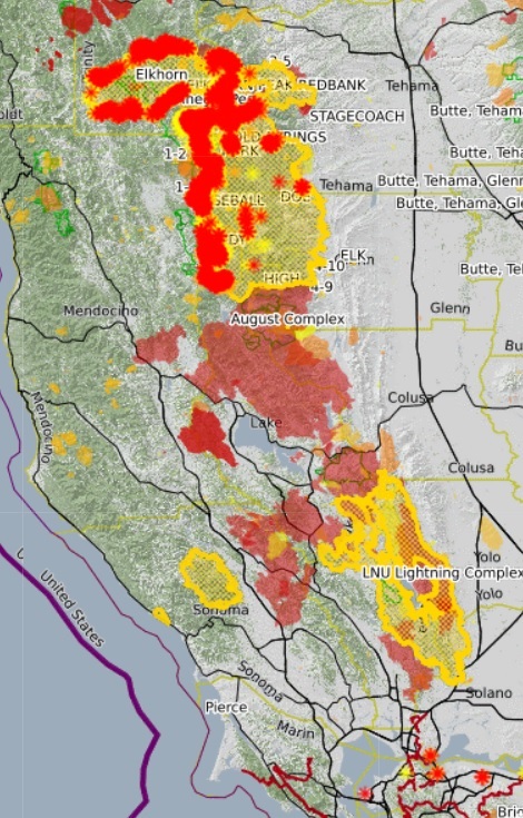
After a reprieve in 2019, we arrive at 2020, where acreage burned has exceeded two million and three million for the first time. We keep having to adjust our vertical axes to make room for each new year. Five fires burning at the same time in 2020 qualified for the top 20 largest fires in the history of the state. Three of those, still burning as a write, are first, second, and fourth on the list.
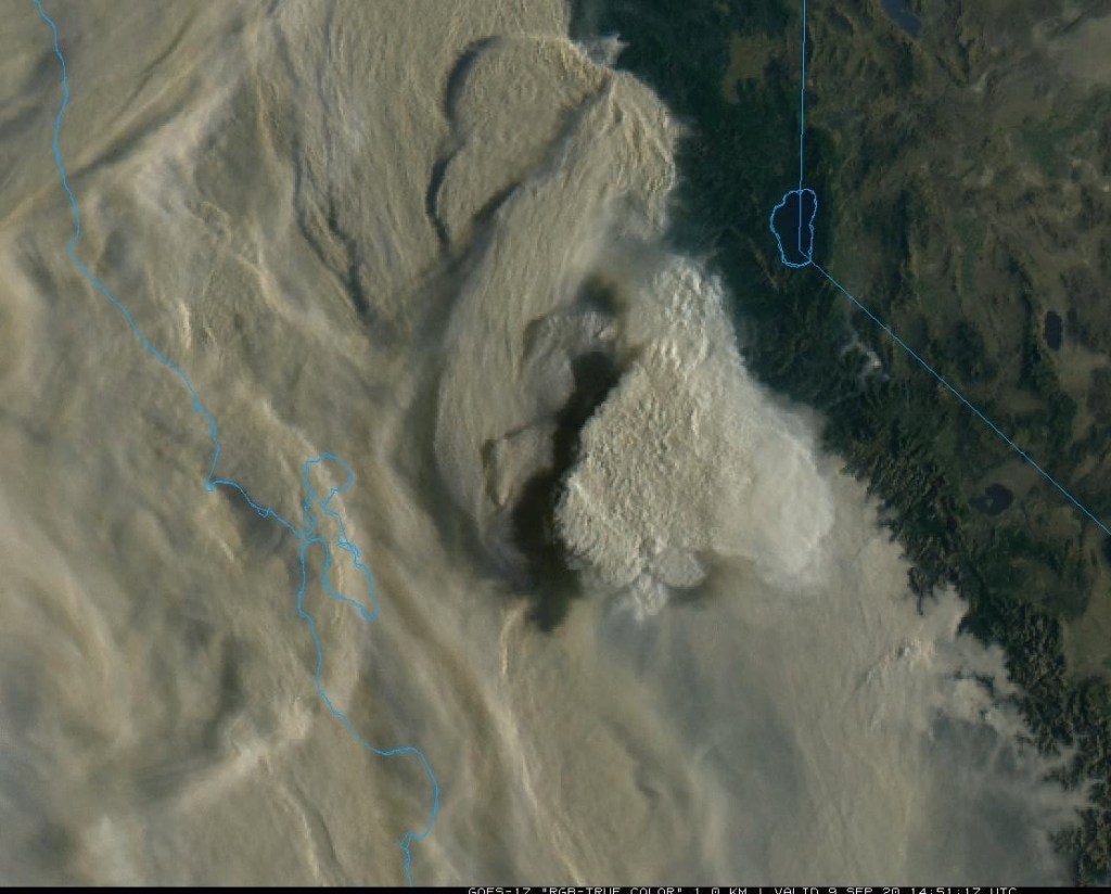
California under smoke, September 9, 2020.
Each year has its macabre highlights. This year, over 300 people were rescued by military helicopters, many at night high in the Sierra. For the first time ever, all 18 national forests were completely closed to the public. The National Weather Service had to create a firenado warning. A dystopian pall of smoke created hazardous air from California to Canada for weeks, forcing people into their homes with all windows shut. And my hometown, Woodland Hills, hit 121 degrees, the highest temperature ever recorded in Los Angeles County.
In 2019, the media reported that Oregon firefighters make an annual trek to California to provide mutual aid. In 2020, that changed. A quarter of the west slope of the Cascades from Portland to Medford appears to be on fire. One out of eight Oregonians are evacuating. The media is filled with horrific stories of grandmothers and teenagers burned alive while the father asks a badly burned woman along a roadside if he’s seen his wife. “I am your wife,” she responds.
Eugene, Oregon on the morning of September 8, 2020.
The process
We have heard for years that, with longer and hotter summers and declining snowpack, fire season has grown by months. In 2006, Westerling predicted such an increase in fires that the forests of the western US would become net carbon emitters. The US Forest Service now plans for fire year-round.
A series of academic analyses lays out the factors and processes of Arizonification. Decreased summer rains, as well as warmer winter and spring temperatures, are creating dry and stressed trees. But that’s not all. Summers that have become 1.4C (2.5F) warmer have led to an exponential increase in atmospheric vapor pressure deficit (VPD). It’s getting drier and, more importantly, vegetation is getting drier. This leads to big fires. Williams et al (2019) noted, “The ability of dry fuels to promote large fires is nonlinear, which has allowed warming to become increasingly impactful.” The Camp Fire, which destroyed the town of Paradise, occurred during some of the lowest vegetation moisture ever recorded. Add to that hot dry winds and vulnerable PG&E transmission lines, and the Paradise disaster looks predictable.
To summarize, slightly warming temperatures, even in winter and spring, and less summer rain lead to an exponential increase in dry vegetation, which leads to an exponential increase in large fires, which leads a conversion of habitat from forest and chaparral to the grass and rock-dominated landscapes of arid desert mountain ranges. Sacramento becomes Phoenix. The Sierra and Coast Ranges become Camelback Mountain.
The future
Nearly the entire east side of the northern Coast Ranges have burned since 2018. Much of the southern Sierra forests died during the recent drought; most of those have yet to burn.
Arizona State University fire historian Prof. Stephen Pyne calls this a new epoch, the Pyrocene. “The contours of such an epoch,” he writes, “are already becoming visible through the smoke. If you doubt it, just ask California.”
Abatzoglou and Williams (2016) conclude, “anthropogenic climate change has emerged as a driver of increased forest fire activity and should continue to do so while fuels are not limiting.” Williams et al repeat this, “Given the exponential response of California burned area to aridity, the influence of anthropogenic warming on wildfire activity over the next few decades will likely be larger than the observed influence thus far where fuel abundance is not limiting.”
In layman’s terms, it’s going to get worse until there’s nothing left to burn.
The annual area burned in California has increased fivefold from 1972 to 2018 (Williams et al 2019). Several individual fires in 2020 exceed the average from 1987-2005. The point shown here for 2020 is still increasing.
Academic papers
Here is a partial list of recent research on the increase of fires in California and the western US.